Heading

End-to-end
data acquisition.
Analytics-ready
data delivered.
The Aerial Data Acquisition Expertise that Your Project Demands
We don't offer a rigid, one-size-fits-all service. Our clients often have specific workflows, sensors, and operational guidelines they need to follow. We work with our clients to provide the level of service that suits their project the best.
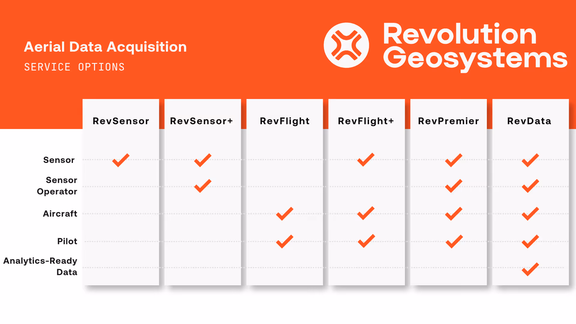
Here's what a typical engagement can include, depending on what your project requires:
- RevSensor: Rent a sensor from our rental fleet to install in your own aircraft
- RevSensor+: Rent a sensor with sensor operator services from our trained team
- RevFlight: Book a RevGeo aircraft and a qualified pilot ready to deploy to your project location
- RevFlight+: Our RevGeo aircraft will come with a rental sensor installed
- RevPremier: With this turnkey service, we do the data acquisition for you and deliver you a LAS file ready for your post-processing workflow
- RevData: True end-to-end aerial data acquisition for a firm, fixed price. You give us your AOI and specs, and we will deliver you analytics-ready data.
What stays consistent across every engagement is the quality of the service we deliver, and where our focus remains. We focus on the hardware, software, and talent side of data acquisition so our clients can focus on what they do best: delivering high quality geospatial products to their end-clients.
Geospatial Data Acquisition Services Built for the Demands of Real Projects
Revolution Geosystems operates one of the world's largest fleets of survey-ready modern aircraft dedicated to geospatial data acquisition. We combine deep aviation expertise with advanced sensor technology to deliver reliable, high-quality airborne acquisition services to mapping professionals across the country and around the world.
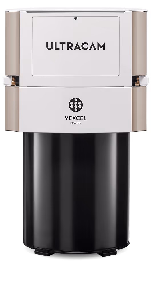
We are built for versatility. From high-density lidar data acquisition to high-resolution photogrammetric imagery and geophysical remote sensing, we configure each mission around your project requirements.
No two projects are identical, and our operation is designed to reflect that. What doesn't change is our commitment to delivering analytics-ready data efficiently, so your team can move directly into production without unnecessary delays between collection and output.
Geospatial projects don't wait. Weather windows close. Deadlines don't move. And when your team needs an aircraft or a sensor in the field, you need a partner who's already ready to move.
That's what we do at Revolution Geosystems. We provide the aircraft, sensors, pilots, and flight operations that geospatial teams need to collect high-quality data so that our clients turn that data into mapping products.
We've been building this operation since 2006. What started as a small aviation company has grown into one of the most capable aerial acquisition platforms in the geospatial industry. If you're pursuing a large federal or commercial contract, managing a project under deadline pressure, or dealing with a sensor failure mid-collection, we're ready to support you.
A Fleet Built for Uptime
Fleet size matters. But fleet standardization is what actually protects your project. We operate a large, modern, standardized fleet of survey-ready aircraft. Because our aircraft are consistent in type and configuration, we stock spare engines, engine accessories, and airframe parts in-house. When maintenance is required, we can move fast. When an aircraft needs to come out of rotation, we have options. Your project doesn't stop because one plane needs attention.
Our maintenance approach is proactive and deliberate. We don't wait for something to break. We maintain aggressively so our aircraft are ready when your project window opens. That means:
- Meticulous pre-mission inspection and safety protocols on every aircraft before every flight
- In-house parts inventory to minimize time between maintenance events
- Repair facilities in Huntsville, Alabama and Palmer, Alaska supporting North American operations
- Partnerships with local maintenance facilities across the U.S. for regionally deployed aircraft
On any given day, our aircraft are operating across the world supporting client projects. That's not a talking point. That's what a fleet of this scale looks like when it's working correctly.
%20(1).avif)
.avif)
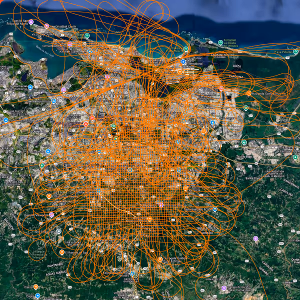
Deep Experience in Data Acquisition Around the World
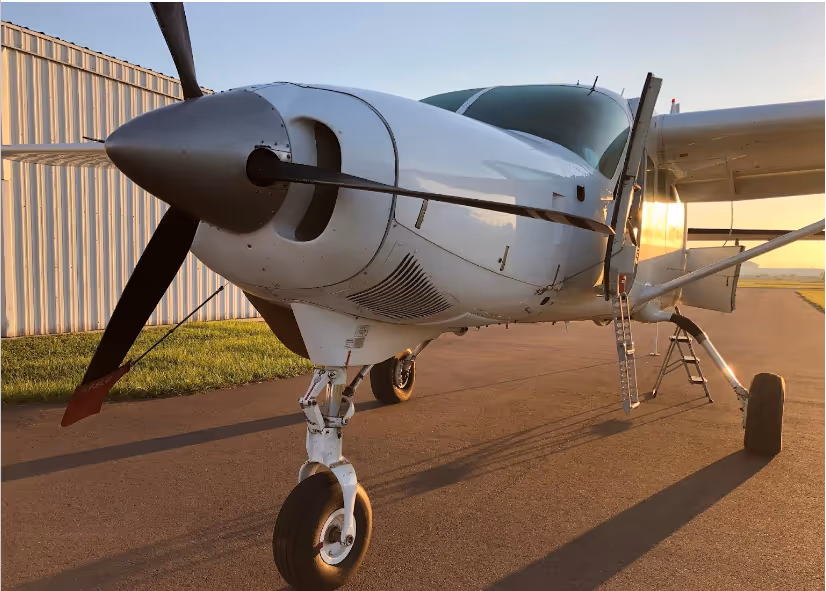
Our fleet of versatile Cessna Caravan aircraft, equipped with single or dual hatches, forms the backbone of our aerial survey capabilities. These modern turbine aircraft are strategically configured to accommodate a range of sophisticated sensors. We offer flexibility to meet your specific project requirements. You can operate your sensors on our aircraft with your own operators or entrust our experienced team with a complete turnkey solution encompassing aircraft, pilot, and sensor operation. This adaptable approach ensures optimal results tailored to your unique geospatial needs.
.avif)
.jpeg)
.avif)
Superior Flight Operations with a Unique Platform
Built to Deploy When It Matters
Speed to field is a real differentiator in our industry. When a project window opens, or when something goes wrong and a client needs support fast, response time is everything.
Our fleet is distributed strategically across the country to support fast regional deployment. When a project requires something more unusual, we will do our best to find a way to make it work.
We've supported clients in situations that required fast, creative problem-solving, including:
- Transporting portable sensor systems as carry-on luggage for international deployments
- Sourcing local aircraft in remote locations and integrating our sensor payload on unfamiliar platforms
- Completing full project mobilization and collection in under a week from initial client contact
- Providing immediate sensor rental support when client equipment failed mid-project and deadlines couldn't move
- Flying our own aircraft to other parts of the world to support data acquisition for clients with no local options
That kind of operational flexibility doesn't come from having a good brochure. It comes from nearly two decades of solving hard problems in the field, building a fleet and a team specifically designed to handle what other providers can't.
When the mission is complex, remote, or time-sensitive, we know how to mobilize.
Ready to Support Your Next Project
We bring the aircraft, the sensors, the pilots, and the operational infrastructure. You bring the mapping expertise. That's a partnership built to perform under pressure.
Whether you need a turnkey aerial acquisition solution, a rental sensor to fill a capacity gap, an aircraft positioned close to your project area, or a team that can mobilize quickly for a complex and time-sensitive project, we're ready to talk through what your work requires.
Request a quote and we'll get back to you as soon as possible.
